Maptitude 2016 is a major new release of Caliper Corporation’s popular GIS (Geographic Information System) and mapping software. The 2016 version provides the most up-to-date and accurate data available.
Maptitude 2016 provides the business value you should expect when investing in mapping software. It includes the latest streets, postal data, and demographics. Maptitude 2016 is the fastest and most intuitive professional mapping application, with significant enhancements to map redraw speeds, territory management, and in the creation of efficient trip plans.
Maptitude 2016 answers specific operational questions with data driven solutions. For example, you can ensure balanced and equal territories using any combination of demographics or sales data. You can create multiple trip plans, schedule stops and stop duration, calculate fuel costs, and create routes.
Maptitude can map your information whether you have data from Google Maps, a Microsoft mapping product (such as MapPoint), or from Microsoft Office. You can analyze your information using the intuitive Maptitude 2016 mapping wizards, and export your results as attractive preformatted Excel or PDF reports.
The most exciting features of Maptitude 2016 are showcased below. A complete description of the many improvements in Maptitude 2016 is available as a PDF here.
Maptitude delivers easy-to-use, professional mapping tools and data at the unbeatable price of only US$695 (or US$395 for upgrades). For pricing and ordering information please visit the Mapping Software Store, e-mail Maptitude Sales, or call us at +1 617-527-4700.
Paul Lucassen
Lucassen
Consulting
Every 2016 Country Package* has a refreshed data set that provides access to the most up-to-date geographic information available. Updated map content allows for accurate address locating and street visualization, as well as robust data on which to calculate shortest paths, drive-time rings, and drive-time territories. Accurate, comprehensive, average traffic speed data are now included.
All New 2016 Country Packages Include:
In addition, country specific changes include:
United States 2016 Country Package:
The U.S. Census boundaries (e.g., Tracts, Counties, MCDs, MSAs,
States) and ZIP Codes contain updated
demographics and Census data such as buying
power/disposable income, banking compliance data, and the
2014 Census ACS data. The 2016 U.S. Country Package also
includes the January 2016 ZIP Code release, ensuring that
you are using the latest nationwide postal data.
More…
Australia:
There is an updated Local
Government boundary layer with 2014 population by age and
gender, an updated postal boundaries layer, an updated
suburb layer, and a new 2016 Ward layer. There is also a new
Address point layer that dramatically improves geocoding
accuracy to the address point level using the G-NAF geocoded
address database.
Brazil:
There is
an updated postal point layer.
Canada:
There are
updated postal FSA boundaries, 6-digit
postal points, and Census Subdivisions
layers.
Germany:
There is
an updated postal boundary layer and improved
address geocoding, especially for
smaller Gemeinden.
United Kingdom:
There are updated postal boundaries,
postcode points, Local Government
(including the new Northern Irish
Districts), Ward, and District layers.
There is also new 2011/2 weekly income
data for England and Wales at the MSOA,
Local Government, County, and Province
layers and 2014 estimated population
data by age and gender at the District,
SOA, MSOA, Local Government, County,
Euro Region, and Province layers.
For additional information on each Package, including those for countries not mentioned here, please visit the Included Mapping Data page.
* 2016 Country Packages are available for: United States, Australia, Brazil, Canada, Germany, Mexico, Netherlands, New Zealand, and the United Kingdom
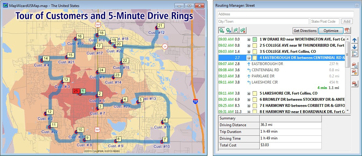
You need the ability to plot accurate stops and to manipulate, manage, and compare routes. Maptitude 2016 gives you these capabilities in a simple Routing Manager tool that allows you to order or optimize your vehicle visits, among hundreds of stops with variable cost and time per stop.
If your vehicles have speed constraints by road type then you can adjust speeds by road category. You can also get a clear overview of your service areas by creating drive-time zones around your starting locations, adjusted by driving speed. The drive-time rings can be concentric, cumulative, have multiple origins, and can produce reports via a single click. (See a video demonstrateing the new routing tools.)

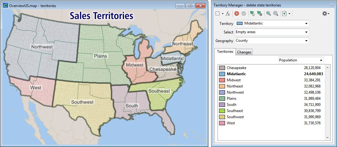
Businesses require robust territory creation tools that excel in both the handling of data tables and in the visual manipulation and representation of service areas. We designed Maptitude 2016 to exceed these requirements with an intuitive Territory Wizard and a sophisticated Territory Manager with complete undo and redo support.
The Territory Wizard provides a step-by-step guide, from data input all the way through to territory creation. Maptitude 2016 will handle all your territory design needs including creating territories from scratch, creating overlapping territories, or creating territories based on tables, filters, sales person, facility location, or from existing map boundaries. (See a video on using the Territory Wizard.)
The Territory Manager can be used to build or modify your territories. These territories can be allowed to overlap, and you can see running totals of demographics or sales data. If you are creating territories based on postal areas, for example, you can still use larger areas such as counties and states to create your regions. (See a video on using the Territory Manager)
Single click exports allow you to see your territory list and corresponding geography, such as postal areas, and also include population reports.

In Maptitude 2016 you can quickly and intuitively create high-quality reports for Microsoft Office Excel or as a PDF.
You can immediately view an Excel demographic report when using the lasso, circle, or rectangle drawing tools, or when analyzing your service areas. The Excel reports enable you to make well-informed location-based decisions using clear and concise results that can be easily shared.
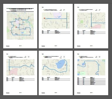
The Maptitude 2016 routing tool provides a strip map report that can be saved to PDF. The new report shows an overview map of the route, along with maps for each leg of the trip, complete with turn arrows, street names, distance traveled, and time taken.
In addition, you can now save your maps to more video formats (that can include audio) and to animated GIFs, both of which allow you to present your map analysis to others throughout your organization.

Listed here are a few more of the many enhancements in Maptitude 2016. For a complete overview of the new features, please see the new features in Maptitude 2016 PDF.
Maptitude now dominates the space vacated by Microsoft MapPoint. Maptitude ships with the latest maps, data, and demographics.
With enhanced versions of the features that Microsoft MapPoint users are familiar with, Maptitude retains the ease-of-use of the MapPoint tools while providing the functionality that Microsoft users could only wish for.
The new and improved tools include:
Speed improvements provide faster access to maps, routes, drive-time rings, and geographic analysis. Maptitude 2016 provides significant speedups in map display with faster drawing of styles, filters, layers, and labels.
Maptitude continues to support the latest data standards and file formats including those for Google Maps, Microsoft MapPoint, and Excel.
For example, Google Earth layers can now be imported along with their associated fields of data, while Microsoft Streets & Trips and AutoRoute users can migrate their pushpins to Maptitude via a simple File-Open. The functionality to easily open MapPoint, Streets & Trips, and AutoRoute data in Maptitude is valuable to users that have invested in these discontinued Microsoft mapping products and who now need to shift to a better application.
Click here to see
features that were new to Version 2015.
Home | Products | Contact | Secure Store