| Summer 2019 Newsletter |

|

|
| Website | Contact Us |Reviews | |
 Census day is only 300 days away. Citizens will be tabulated for 2020 and redistricting will officially begin. Now is the time to make sure your redistricting software is up to date, your staff are hired, and you are prepared for the road ahead. Are You Ready? ~ Benjamin Franklin Contact Us to ensure your licenses are up-to-date, to obtain additional licenses or to become a new customer.
|
||||
| Professional Redistricting Tools — No Experience Required! | ||||
| Maptitude for Redistricting 2019 has new Partisan Competitiveness reports, adds access to imagery layers, and allows you to save and share your plans in a variety of formats. Partisan Competitiveness Reports Evaluate the partisan competitiveness of districts using the Efficiency Gap measure, Declination and Mean-Median Difference. These measures provide valuable insight on the composition of your districts when using political data. More... Access to Imagery Layers No one knows your districts better than you. Add aerial, road, terrain, and hybrid map layers (including OpenStreetMap, USGS Topographic Maps, and USGS Aerial Imagery) that can serve as distinctive backgrounds to your redistricting plans. More... Save and Share Your Plans in a Variety of Formats Maptitude for Redistricting makes sharing your plans easy. Quickly produce Census Block to District equivalency files to maintain plan relationships. Create Google Earth Documents (KML/KMZ) to share online and with mobile devices. Export to other standard GIS file types — the choice is yours. More... |
||||
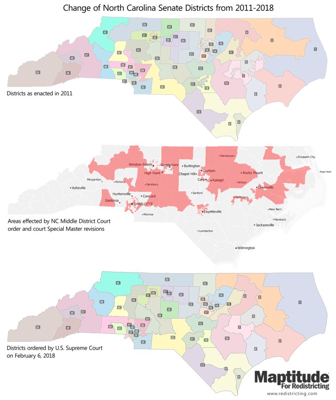
| Featured Map: North Carolina Senate District Changes |
||||

|
||||
| »
More about this map and other featured maps
|
||||
| How do I Learn to Use Maptitude for Redistricting 2019? | ||||
|
||||
| Tech
Tip: How do I use the Cut Edges test to measure compactness in Maptitude for Redistricting 2019? |
||||
The Cut Edges test in Maptitude for Redistricting 2019 counts the number of edges removed from the adjacency (dual) graph of the base layer — usually Census Blocks — to define the districting plan. The smaller number returned implies a more compact plan.
*Cut edges is a new compactness measure recently proposed by Moon Duchin & the Metric Geometry and Gerrymandering group. |
||||
|
Learning:
Training: September 24-26, 2019 • Newton MA, USA • Details | Register
|
||||
| www.Redistricting.com | ©2019 Caliper Corp. All Rights Reserved. |
|
|
