|
|
 Maptitude
Spotlight: Maptitude
Spotlight:
$100 Off
Country Packages: Low Price for Only 2
Weeks!
|
|
Do you have locations in
Europe? Are you
expanding in
India, or do you require
mapping for the
Americas? Now is the
time to explore your international
markets with Maptitude.
For a short time we are offering our
suite of
Country Packages for only US$495!
This deal saves you
US$100 per
Country Package!
Each Package supports the full Maptitude
toolset for the chosen Country, enabling
detailed market and location analysis.
The Country Packages are updated and
current.
Get the most detailed
and accurate
data and demographics ever
available.
For pricing and ordering information
please visit the
Mapping Software Store, e-mail
Maptitude Sales, or call U.S. Sales
at +1 617-527-4700.
Limited Offer: Valid until June 15, 2013,
& for new orders only.
Restrictions Apply.
|
You need the newest maps, the latest demographics,
and the fastest, most
intuitive Maptitude!
  |
|
|
Maptitude Classroom Training:
Limited Availability!
Maptitude 2013 Training:
Boston, MA /
London, England |
|

The
next scheduled instructor-led training courses will be
October 21-23 in Boston MA (USA) and
December 16-17 in London, England (UK). Advance
registration is required.
The new and updated curriculum reflects
the features in Maptitude 2013.
Space is limited, so
register online as soon as possible.
If you have any questions, please call Maptitude
Training (USA) at +1 617-527-4700, or send
an e-mail to
sales@caliper.com.
|
|
|
|
Caliper also offers several training options:
•
Instructor-led classroom training
•
Private training
•
Web-based training
•
Free Learning Resources
•
Free Mapping Software Webinars
|
|
Free Mapping Resources: |
|
This month's free resource is
registration for a Maptitude mapping
software live webinar hosted by expert
training staff. Q&A sessions are
included and the most commonly used
tools in the software are covered.
Webinars are now held at 10am and 1pm
EDT (GMT -5 hours) allowing a
wider audience to attend.
•
Free Mapping Software Webinars
|
|
|
International News:
Maptitude Country Packages Now Cover 19
Nations |
|

There
are now
19 Country Packages
available for Maptitude 2013!
The countries covered include: 3
of the 5 fast-growing BRICS
economies:
Brazil, South Africa,
and India; 6 of the Group of
Seven (G7) nations; and 12 of
the Group of Twenty major
economies.
Caliper
is excited to be able to bring
the power and flexibility of our
Maptitude product suite to a
global audience and to enable
our customers to make
geo-location based decisions
internationally.
Maptitude ships with one country
of your choice (see
complete list), and additional
Packages can be purchased separately
for US$595.
You can seamlessly switch between
the countries purchased.
Doing so refreshes the Maptitude
interface with country-specific
tools such as those for finding,
pin mapping (geocoding), routing,
displaying demographics (where
available), and the Create-a-Map Wizard.
If you have any questions, please
call Maptitude Sales (USA) at +1
617-527-4700, or send an e-mail
to
sales@caliper.com.
|
|
| |
Did You Know?
Multiple Line Labels |
|

You
can label map features such as
customers with values from more
than one field in your data,
such as name and revenue.
To
use multiple fields to label
features,
click the label icon in the Display Manager
to show the Labels box for a
layer, and choose "Multiple
Fields" as the field to use for
labeling. Maptitude then displays the
Multiple Fields in Label
box. Each field is displayed on
a separate line in the label,
and can even have different
coloring to enable you to better
distinguish the values.
|
|
| |
|
|
| |
|
|
Featured Data Product:
ZIP Codes (USA) with Census Demographics |

Do
you make business decisions based on postal data? The
ZIP Codes data is refreshed quarterly to ensure that
you are using up-to-date nationwide United States Postal
Service definitions.
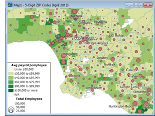
The April 2013 ZIP
Codes product is now available and contains:
•
A nationwide area database
with ZIP Codes for all 50 states, the District of Columbia, Puerto
Rico, and the territories.
•
A point database of ZIP
Code centroids and 3-digit ZIP Code Areas for the entire country.
•
Demographic data at no additional cost, including more than 400 fields
from the 2011 ACS and 2010 U.S. Census for population, age, marital
status, education, occupation, industry, race, income, housing
values/ characteristics/ loans, rentals vs. owners, gender,
Hispanic origin, mode of travel, and households by type.
•
3-digit and 5-digit ZIP Code area 2009 ZIP Code
Business Patterns (ZBP) NAICS codes with the number of businesses by
detailed industry type (retail, finance, etc.), the number of
employees and annual payrolls, and a classification of rural-urban
commuting characteristics.
Price: US$250.
Call Maptitude
Sales (USA) at +1 617-527-4700.
|
Tech Tip:
Creating 3D
Themes of Map Data |
|
Thematic maps illustrate the characteristics of map
features, so that the characteristics are easy to see
and understand. A map theme is a styling of map features
according to the values of one or more data fields such
as sales volume by Postal/ZIP Code.
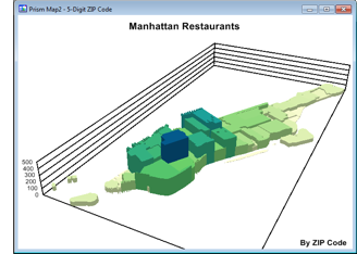
A 3D heat/color theme (Prism Map) uses 3-D imaging and
color to show the relative values of a single data
field. Prism Maps can only be created on an area layer,
such as counties, states, or sales territories.
The
following steps illustrate how to show areas in 3D using the
Prism Map tool in Maptitude 2013:
-
 Show
your data attached/joined to boundaries (e.g.
Postal/ZIP Codes) on a map. Show
your data attached/joined to boundaries (e.g.
Postal/ZIP Codes) on a map.
-
In the Display Manager (Map-Display Manager),
right click on your area layer. This is often a
postal layer such as "5-Digit ZIP Code" in the USA.
Choose Make Working Layer.
-
Choose Map-Prism Map to
display the Prism Map Properties dialog box.
-
Choose a data field from the Field
drop-down list.
-
Chose whether to map All Features, only Visible
Features, or a filtered set of areas from the
Selection drop-down list.
-
Click the Styles tab to display the
Styles page.
-
Choose Color Ramp, then choose a
starting and ending color, or click
<<Previous Set or Next Set>>
to browse through the available color ramps.
-
Click OK.
Maptitude draws the prism map in a new figure window.
|
Featured Maptitude Maps:
Using GIS To Manage An
Election: Expected Voter
Turnout |
|
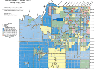
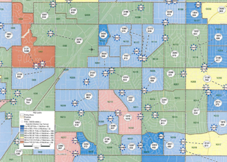
This month we showcase
Maptitude maps created by
Johnson County (KS, USA) showing expected voter turnout
for a presidential election.


(Maps: Connie Schmidt, Election Commissioner,
Johnson County, May 2004)
If you would like to see your maps showcased here, please
contact
Caliper.
|
|


