|
|
Focus On
Maptitude:
Is Maptitude
The Best Mapping Software For Your
Organization? |
|
Maptitude is used in a diverse array of industries
globally. It has earned the label of the easiest-to-use
professional mapping application. In addition, the
generic feature set and extensive data in Maptitude
means that it can be used to solve problems
out-of-the-box in almost any organization that requires
location-based analysis of their data.
The versatility of the software has
saved businesses money and continues to
improve our customers' operational efficiency. Maptitude has a price point
that cannot be beaten by other players
in the burgeoning geospatial industry, a
sector that is worth up to $270 billion
per year.

Several testimonials on the use of Maptitude
in various sectors are listed here:
| • |
Banking: "We
switched to
Maptitude....You can map
your loans and the
census tracts are
updated for 2010 Data."
-CRCM
Compliance Officer;
Maptitude is wonderful.
It is what I use." -Kathleen
Blanchard CRCM
|
| • |
Retail: "I believe
that Caliper's Maptitude continues
to provide more GIS-related features
and more flexibility in defining and
presenting data and map layers than
MapPoint does."
-Steve Hendel, Office Depot
|
| • |
Site Location: "Want to know
whether a certain franchise is
really a good opportunity in your
area, you could profit from a GIS.
Unfortunately, GIS software...has
been rather hard to use, and the
demographic data needed to make it
worthwhile has often been
frightfully expensive. That is now
changing [with] Maptitude." -L.A. Times
|
| • |
Healthcare: "Maptitude supports
many different GIS formats which are
simply not available in other GIS
software...[and] has a significantly
flatter learning curve than other
GIS software. You get a fully
functional GIS and extensive data
for 1/3 the price of other GIS
products." -Dr. Richard E. Hoskins
Washington State Dept. of Health
|
The
expert Maptitude Sales team is here to help you with
your requirements for mapping software, data, and
demographics. Our goal is to help you stretch your budget, advance your mission, and get you and
your organization ready ..... The Maptitude Sales
team provides an unparalleled commitment to excellence
by supporting the many businesses that use the Maptitude
Mapping Software to fulfill their geospatial needs.
Please contact our
Maptitude Sales Team with any questions.
Price:
Maptitude costs US$695 & upgrades are US$395 per user/license, with a free download.
Order online at the Caliper Store now or call Maptitude
Sales (USA) at +1 617-527-4700.

|
|
|
Maptitude Classroom Training:
Limited Availability!
Maptitude 2013 Training:
 Boston, MA /
 London, England
 |
|
 The
next scheduled instructor-led training courses will be
October 21-23 in Boston MA (USA) and
December 16-17 in London, England (UK). Advance
registration is required. The
next scheduled instructor-led training courses will be
October 21-23 in Boston MA (USA) and
December 16-17 in London, England (UK). Advance
registration is required.
The new and updated curriculum reflects
the features in Maptitude 2013.
Space is limited, so
register online as soon as possible.
If you have any questions, please call Maptitude
Training (USA) at +1 617-527-4700, or send
an e-mail to
sales@caliper.com.
|
|
|
|
Caliper also offers several training options:
•
Instructor-led classroom training
•
Private training
•
Web-based training
•
Free Learning Resources
•
Free Mapping Software Webinars
|
|
|
|
Free Mapping Resources: |
|
This month's free resource is
the Maptitude YouTube Channel
that includes both official
and user submitted videos. These
include a 2-part series that
shows how to create a
Huff Gravity Model,
which is a method often used in
retail market
potential analysis.
|
|
| |
|
|
| |
International News:
View Major Storms:
Mexico |
|
Maptitude
ships with powerful tools to allow you to explore international
weather patterns.
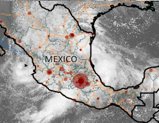
 This month, Tropical Storm Manuel traveled over Mexico's
southwestern Pacific shoulder with heavy rains while Hurricane
Ingrid weakened to a tropical storm after making landfall on the
country's eastern coast. These weather patterns can be observed
directly within Maptitude. This month, Tropical Storm Manuel traveled over Mexico's
southwestern Pacific shoulder with heavy rains while Hurricane
Ingrid weakened to a tropical storm after making landfall on the
country's eastern coast. These weather patterns can be observed
directly within Maptitude.
To view and analyze weather
pattern images for North America
choose
Tools-Imagery-WMS Image Toolbox.
This tool ships with a "Near
Real-Time Observations" web map
service (WMS) provide by NOAA's
nowCOAST. This is a
GIS-based web mapping portal
providing integrated, one-stop
access to on-line, real-time
coastal environmental
observations and NOAA
forecasts.
Most WMS can be used with the tools in Maptitude. Please see
"Using Web Mapping Service Images" in
the Maptitude Help for
further information.
|
|
| |
Did You Know?
Healthcare Data in Maptitude |
|
 In
addition to the latest
demographics, Maptitude includes
substantial social, housing, and
income data, along with
easy-to-use analysis tools that
will allow you to better
understand the relationships
between the demand and supply of
medical services. (See
healthcare maps here) In
addition to the latest
demographics, Maptitude includes
substantial social, housing, and
income data, along with
easy-to-use analysis tools that
will allow you to better
understand the relationships
between the demand and supply of
medical services. (See
healthcare maps here)
For example,
Maptitude Country Packages include
comprehensive hospital
locations, and the
Maptitude USA Package also
includes the number of
health care and social
assistance employees and
establishments for every ZIP
Code in the country. These data
provide a complete framework for
exploring care provider
locations.
|
|
| |
You need the newest maps, the latest demographics,
and the fastest, most
intuitive Maptitude!
  |
|
|
Maptitude Spotlight:
Using
Outdated Data & Technology? Upgrade to
Maptitude 2013!
|
|
 Users of Maptitude 2012 and Maptitude
6.0 can still get our US$395
reduced upgrade pricing. This
deal
saves you US$300! Upgrade now to avoid
being caught out by using last year's
features and data. Users of Maptitude 2012 and Maptitude
6.0 can still get our US$395
reduced upgrade pricing. This
deal
saves you US$300! Upgrade now to avoid
being caught out by using last year's
features and data.
Also, each US order will include a free US
ZIP Code update: a US$250 value! The
combination of the offer and free data saves
you US$550!
Maptitude 2013 is a major new release.
Upgrade to get the most detailed
and accurate
data and demographics ever included.
For pricing and ordering information
please visit the
Mapping Software Store, e-mail
Maptitude Sales, or call U.S. Sales
at +1 617-527-4700.
Limited Offer: Valid for Maptitude 6.0
or later.
Restrictions Apply.

|
Tech Tip:
Analyze
Populations & Their Health Care Accessibility |
|
 The dynamics of health and health care provision
vary substantially across regions, and Maptitude
allows you to map these differences in population
density, age distribution, disease prevalence, race,
ethnicity, poverty and the ability to access care.
Maptitude includes the geocoding and geographic
information system (GIS) tools that are critical in
linking patient and population locations to local
demographics to explore these relationships. The dynamics of health and health care provision
vary substantially across regions, and Maptitude
allows you to map these differences in population
density, age distribution, disease prevalence, race,
ethnicity, poverty and the ability to access care.
Maptitude includes the geocoding and geographic
information system (GIS) tools that are critical in
linking patient and population locations to local
demographics to explore these relationships.
Maptitude is widely used to conduct research in the
health care sector and in the fields of public
health, disease mapping, and epidemiology. Maps help
to visualize health care information and enhance the
understanding of the health care landscape.
Maptitude mapping software enables users to
find data about hospitals, health workers, at risk
populations, and more.
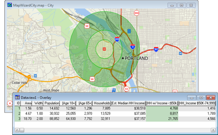
The
following steps illustrate how to create rings around
hospitals and to identify those people able to
access these medical service locations:
-
Choose File-New,
choose Map
from the New File dialog box, and
create a General Purpose map of your study area.
-
In the Display Manager, expand the Landmark
layer branch, and then the Landmark
Feature Display branch.
-
In the Landmark Feature Display
branch, right-click
on Hospital and choose Show
Feature Class.
The hospitals are displayed on the map.
-
Make the Landmark layer the working
layer by choosing it from the drop-down list on the
Standard toolbar or by right-clicking on the layer in
the Display Manager and selecting Make
Working Layer.
-
Using the Select by Pointing tool, click on a
hospital location in the map to filter it for
further analysis.
-
Choose Tools-Geographic Analysis-Bands.
Choose the Fixed Sizes method, type "0.5, 1,
2" in the Sizes edit box, and choose the units for
the rings.
-
Click the Overlay tab, check
Compute Overlay, and click
OK.
-
When prompted, type a file name for the new
ring/bands map layer, and click Save.
Maptitude creates the rings and adds the new layer to
the map.
-
Choose Window-Tile Horizontally.
You should now have a map and a table/dataview
window visible. The Overlay table
shows the demographics of the hospital's service
area.
To insert your results into a presentation you can
choose File-Save As for each
window to export your map and table for use outside of
Maptitude.
|
Featured Maptitude Maps:
Toxic Release Inventory
Reporting Facilities and Seismic Hazards |
|
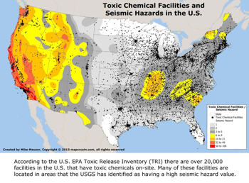
This month we showcase a map created by Maptivist.com. "The
recent nuclear catastrophe in Japan makes it crystal
clear that nuclear facilities in seismic hazard
zones are at high risk. Similarly, facilities in
seismic hazard zones that store and use quantities
of toxic chemicals are also at high risk to
accidents resulting in environmental and human harm."

Map:
MapCruzin/Maptivist
More Featured Maps...
If you would like to see your maps showcased here, please
contact
Caliper.
|
|

