NEWTON MA (USA) -
Commercial
realtors need to analyze client
locations in relation to properties.
Delivery companies need to be able to
create vehicle routes that have
different characteristics. Franchises,
retail chains, and hospitals need to
know where their customers are in
relation to their locations. Maptitude
2017 (us$695) makes it easier-than-ever to meet
these requirements. Here are 4 key areas
where Maptitude 2017 will prove critical
for your organization:
-
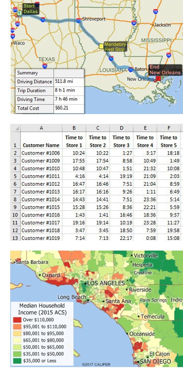
Routing: The Routing Manager can
create a route that is optimized using the latest street data, apply a default
vehicle stop time or read stop times
from an Excel table, and lock the first
and last stops. A list of route stops can be immediately
exported to Excel along with the longitude and latitude of each
stop.
-
Logistics: The Distance and Travel Time Tables Tool
creates an Excel table that lists the costs of travel between
any number of origins and destinations. You can now quickly
identify the closest and backup locations ranked by travel
distance or time.
-
Reports: The Radius Drawing
Tool is used to draw a circle anywhere on a map. You then right
click on the circle to export to an Excel report the travel time
and distance from the location clicked on to all locations
within the circle.
-
Software
and Data: Many MapPoint users have switched to
Maptitude, but there is still widespread use of MapPoint. Using
MapPoint is detrimental to your business operations and destroys
the credibility of your reports because the data you are using
was outdated even at the time of release. Maptitude 2017 ships
with the most up-to-date geographic and demographic information
available. Maptitude also includes all the key features and
tools of MapPoint.
There are many
more improvements in Maptitude 2017!
Please
contact the
Maptitude Sales Team
with any questions.
“We have found Maptitude to be a really
useful piece of software. It allows us to quickly and easily
represent various data geographically, and the ease of functionality
and ability to layer data makes it really user friendly.
It has, among other things, helped us develop our sector-leading
delivery service and understand areas that require focus from our
sales teams.”
Richard Horton,
Transport Development and Planning Manager,
Travis Perkins PLC,
UK
About Caliper
Caliper Corporation
develops state-of-the-art
Geographic Information Systems (GIS) software. With a focus on
usability,
Maptitude is designed to be a cost-effective, professional
mapping software product. Maptitude enables organizations to
leverage their location-based data to improve decision making and
planning, while minimizing expenditure through competitively priced
solutions.
Caliper is a privately held corporation and is a leading developer
of mapping,
redistricting,
transportation, and
GIS software.

“We have found Maptitude to be a really
useful piece of software. It allows us to quickly and easily
represent various data geographically, and the ease of functionality
and ability to layer data makes it really user friendly.
It has, among other things, helped us develop our sector-leading
delivery service and understand areas that require focus from our
sales teams.”
Richard Horton,
Transport Development and Planning Manager,
Travis Perkins PLC,
UK