Land use mapping involves identifying and
delineating the different human activities and land uses within a
geographic area. This process helps to characterize the spatial
distribution and intensity of activities such as residential,
commercial, industrial, agricultural, and recreational land uses.
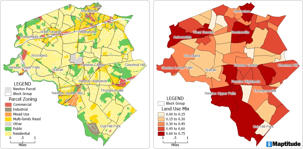
Land use mapping of zoning in Newton,
Massachusetts (left) and can be used to quantify access to different
land use types (right)
Benefits of Land Use Mapping
- Provides insights into how land is utilized across different
areas.
- Helps organizations make informed decisions about land use
and development.
- Supports businesses in identifying optimal locations for
facilities or services.
- Reveals patterns, accessibility, and relationships between
different land use types.
Land Use Mapping Features of Maptitude
- Customizable Land Use Layers
- Visualize multiple land use types (residential,
commercial, industrial, agricultural, recreational)
- Turn layers on/off for flexible map views
- Highlight specific areas for focused analysis
- Data Integration
- Import and combine zoning data, demographic information,
and satellite imagery
- Merge multiple datasets for comprehensive geographic
insights
- Maintain up-to-date information for accurate mapping
- Spatial Analysis Tools
- Measure distances and calculate areas
- Analyze accessibility to services, amenities, or
facilities
- Identify patterns, clusters, or gaps in land use
- Reporting and Visualization
- Create professional maps, charts, and reports
- Export visualizations for presentations or stakeholder
communication
- Share insights clearly with decision-makers
Applications of Land Use Mapping with Maptitude
- Understand how land is being used across different areas and
regions.
- Track changes in land use over time for better
decision-making.
- Identify optimal locations for businesses, services, or
facilities.
- Analyze relationships and accessibility between different
land use types for strategic planning.
GIS Software for Land Use Mapping Analysis
Maptitude Mapping Software
gives you all of the tools, maps, and data you need to analyze and
understand how geography affects you and your business. Maptitude includes
tools for land use mapping.
Learn More Free Trial Free for Students/Teachers


