

Author:
Stewart Berry
Images: Dan Martin
5 August 2024
In today's rapidly evolving healthcare landscape, ensuring equitable access to medical services remains a critical challenge. Geographic barriers, population distribution, and resource allocation often complicate the efficient delivery of healthcare. This is where Maptitude, a versatile Geographic Information System (GIS), steps in to offer transformative solutions. By leveraging the capabilities of Maptitude, healthcare providers, policymakers, and planners can make informed decisions to enhance healthcare access, ultimately improving health outcomes for communities.
Healthcare access involves more than just availability; it includes affordability, convenience, and quality of care to achieve the best health outcomes. Barriers to healthcare access can lead to disparities in health outcomes, particularly in underserved areas.
One of the most significant barriers to healthcare access is geography. Rural and remote areas often face a scarcity of healthcare facilities and providers, making it difficult for residents to receive timely and adequate care. Urban areas, while having more facilities, can still have access issues due to traffic congestion, for example.
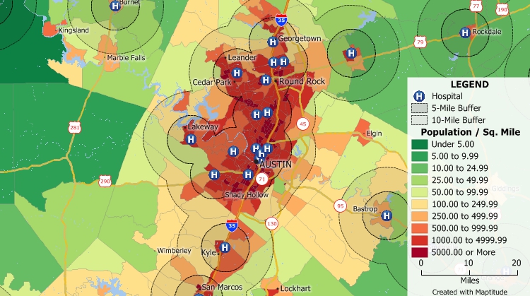
Analyze populations and their healthcare accessibility
Population distribution affects healthcare access in multiple ways. High-density areas may experience overburdened facilities, leading to long wait times and reduced quality of care. Conversely, sparsely populated regions may lack the necessary infrastructure to support comprehensive healthcare services.
Effective resource allocation is crucial for optimizing healthcare access. It involves distributing healthcare resources, such as hospitals, clinics, and medical personnel, based on the needs of the population. Inefficient allocation can result in both underserved and over-served areas, exacerbating health disparities.
Maptitude is sophisticated GIS software that enables users to visualize and analyze geographic data. By integrating various data sources, Maptitude provides comprehensive insights into healthcare access issues. Here are some ways Maptitude can be utilized to enhance healthcare access:
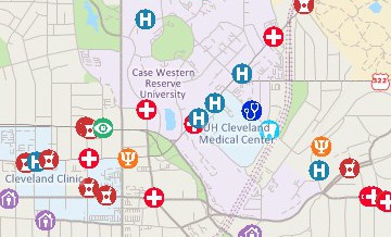
Healthcare deserts are areas with limited or no access to healthcare services. The spatial analysis capabilities of Maptitude allow users to identify these regions accurately. By overlaying healthcare facility locations with population data, Maptitude can highlight areas that lack sufficient healthcare services. This information is invaluable for policymakers and healthcare providers seeking to target their interventions effectively.
Healthcare facility locations
Strategic placement of healthcare facilities is crucial for maximizing access. Maptitude enables users to perform site suitability analyses by considering various factors such as population density, transportation networks, and proximity to existing facilities. This ensures that new healthcare facilities are located where they are most needed, reducing travel times and improving access for underserved populations.
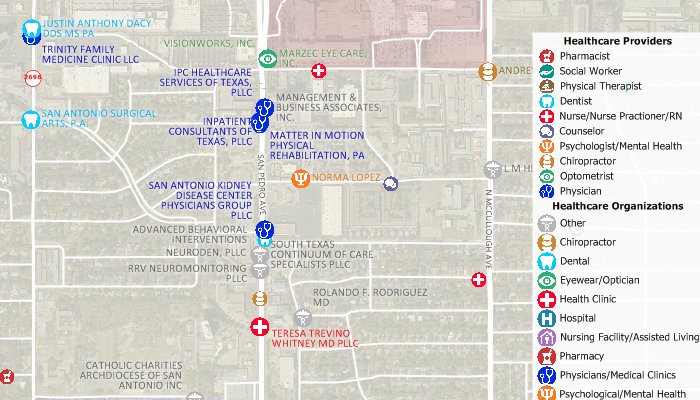
Map patient, doctor, and facility locations
Travel time is a critical factor in healthcare access. Maptitude has routing and network analysis tools that allow users to calculate travel times to healthcare facilities from different locations. This analysis can help identify areas where residents face excessive travel times, guiding efforts to reduce these barriers. Additionally, Maptitude can model different scenarios, such as the impact of new transportation infrastructure on travel times to healthcare facilities.
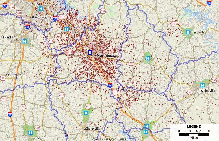
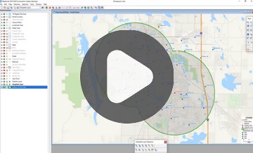
Service area analysis is essential for understanding the reach of healthcare facilities. Maptitude can generate service area maps that show the geographic extent of a facility's influence. This helps healthcare providers understand which areas are covered by their services and identify gaps that need to be addressed. Service area analysis also aids in resource allocation by ensuring that facilities are strategically positioned to serve the maximum number of people.
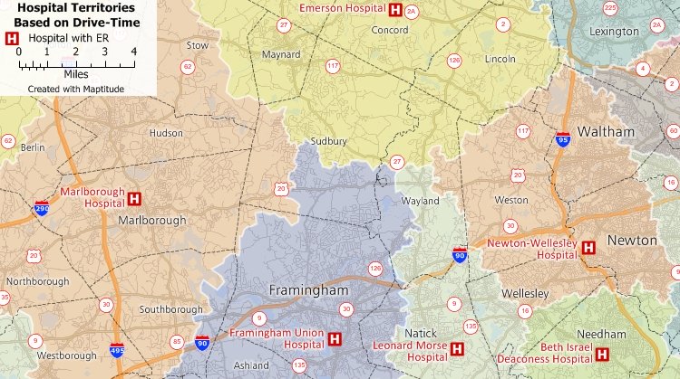
Healthcare service areas
Maptitude allows users to analyze healthcare utilization patterns by integrating patient data with geographic information. By mapping patient locations and their utilization of healthcare services, users can identify trends and disparities in access. This analysis can reveal areas with high demand for healthcare services and those with unmet needs, guiding efforts to balance the distribution of healthcare resources.
Improving healthcare access is ultimately about enhancing health outcomes. Maptitude can be used to monitor health outcomes across different geographic areas, providing insights into the effectiveness of interventions. By tracking key health indicators and correlating them with access to healthcare services, Maptitude helps users understand the impact of their efforts and make data-driven decisions for continuous improvement.
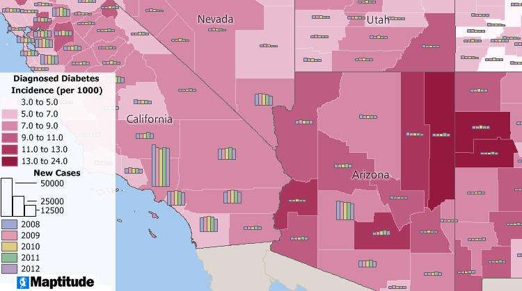
To illustrate the practical application of Maptitude in enhancing healthcare access, let's consider a case study based on Alabama’s Rural Health Plan.1
Alabama faces significant challenges in providing healthcare to its rural residents. Long travel distances to healthcare facilities, coupled with a shortage of medical professionals, contribute to healthcare access disparities. The state needed a strategic approach to optimize the placement of new healthcare facilities and improve access for underserved communities.
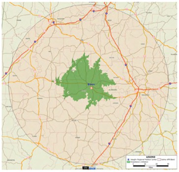
Selma has insufficient family physicians to cover the population within the 30-minute driving time
Using Maptitude, the Office for Family Health, Education, and Research at the UAB School of Medicine, Huntsville Regional Medical Campus, conducted a comprehensive analysis of healthcare access across the state.
The study confirmed that rural hospitals are strategically located to serve as centers for primary care access. However, the supply of primary care physicians, particularly family physicians, was found to be inadequate to meet the demand in rural Alabama. The analysis showed that Alabama needed an additional 76 family physicians in 25 locations, 23 of which were in rural areas.
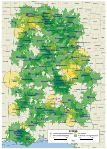
Coverage and areas of need in Alabama’s primary care coverage. Green areas are adequately covered. Yellow areas have need to expand their coverage to 30-minute limitation
As a result of the analysis, Alabama has a foundation for strategic interventions to enhance healthcare access:
This case study demonstrates how Maptitude facilitated data-driven decisions that can directly improve healthcare access for residents in rural Alabama.
To illustrate the practical application of Maptitude in enhancing emergency general surgery (EGS) care, let's consider a case study based on identifying and addressing disparities in access to EGS services in underserved and rural communities across the United States.2
Many counties in the United States lack adequate access to hospitals providing emergency general surgery services. Factors such as geographic location and sociodemographic characteristics contribute to uneven distribution of EGS facilities, exacerbating healthcare disparities.
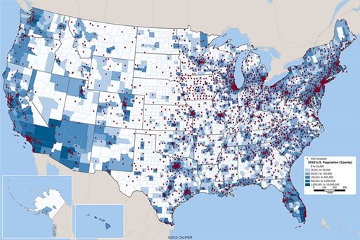
Locations of Emergency General Surgery Hospitals Overlaid on County Population
Using Maptitude GIS software, researchers conducted a comprehensive analysis to assess national EGS capacity and county-level determinants of access. Key steps included:
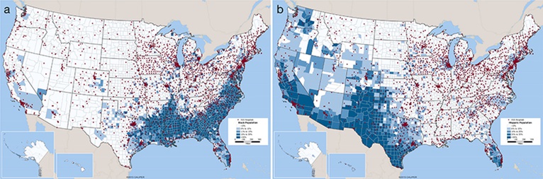
Locations of Emergency General Surgery Hospitals Overlaid on County Population by a) Race (Percent African American) and b) Ethnicity (Percent Hispanic)
The analysis revealed significant disparities in access to EGS care:
By using Maptitude GIS software, policymakers gained insights into geographic areas and sociodemographic groups most in need of improved EGS access. This facilitates targeted interventions to enhance healthcare infrastructure and reduce disparities in emergency surgical care across the USA.
The case studies exemplify how Maptitude can be a powerful tool for enhancing healthcare access. As healthcare challenges continue to evolve, the need for innovative solutions becomes increasingly important. Maptitude offers several advantages that make it an invaluable asset for these applications:
The capabilities of Maptitude can be scaled to address healthcare access issues at various levels, from local communities to entire states or countries. Its flexibility allows users to tailor analyses to specific needs and contexts, ensuring that interventions are both effective and efficient.
The ability of Maptitude to integrate with diverse health data sources, including electronic health records, public health databases, and demographic information, enhances its analytical power. This integration enables a holistic understanding of healthcare access issues and facilitates comprehensive solutions.
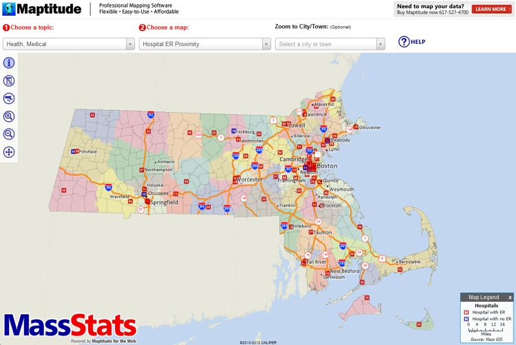
Thematic Map of Healthcare Data
With the increasing availability of real-time data, Maptitude can provide up-to-date insights into healthcare access. This real-time analysis is crucial for responding to emerging challenges and making timely decisions that improve health outcomes.
Maptitude Online supports collaboration by allowing users to share maps, analyses, and reports with stakeholders. This fosters a collaborative approach to addressing healthcare access issues, ensuring that all relevant parties are informed and engaged in the decision-making process.
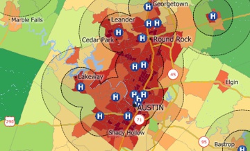
Online Map of Healthcare Data
Enhancing healthcare access is a multifaceted challenge that requires innovative solutions and data-driven approaches. Maptitude, with its powerful GIS capabilities, offers a comprehensive platform for analyzing and addressing healthcare access issues. By identifying healthcare deserts, optimizing facility placement, analyzing travel times, assessing service areas, evaluating healthcare utilization, and monitoring health outcomes, Maptitude empowers healthcare providers, policymakers, and planners to make informed decisions that improve access to healthcare services.
As we move forward, the integration of advanced GIS tools like Maptitude will be essential in ensuring that healthcare access is more equitable, efficient, and responsive to the needs of all communities. By leveraging the power of Maptitude, we can work towards a future where healthcare access is no longer a barrier to achieving the best health outcomes for everyone.
Learn more about Maptitude and the benefits of mapping software for healthcare!
Schedule a Free Personalized Demo
 Check out our G2 Reviews
REFERENCES
1. "Alabama’s Rural Health Plan: An Analysis of Access to Primary Care in Rural Alabama." Published by The Office for Family Health, Education and Research, UAB School of Medicine, Huntsville Regional Medical Campus, January 1, 2013. Accessed July 24, 2024. https://www.caliper.com/press/ruralhealthplan.pdf
2. Khubchandani, Jasmine A., Connie Shen, Didem Ayturk, Catarina I. Kiefe, and Heena P. Santry. "Disparities in Access to Emergency General Surgery Care in the United States." PMC 2019 Feb 1. https://www.ncbi.nlm.nih.gov/pmc/articles/PMC6071308/.
Home | Products | Contact | Secure Store
