|
Case Study:
How CKE
Grew Their Franchise Business with
Maptitude
 As
the CKE Restaurant Holdings, Inc.'s two
popular restaurant brands, Carl's Jr.
and Hardee's, grow in the U.S. and in
several international markets, managing
franchise territories has become more
complex, while the need to integrate
disparate sources of business data has
escalated. To overcome this, CKE relies
on Maptitude to simplify territory
identification and allocation, as well
as to improve franchisee satisfaction
by providing insightful market
intelligence thereby increasing
opportunities for success. As
the CKE Restaurant Holdings, Inc.'s two
popular restaurant brands, Carl's Jr.
and Hardee's, grow in the U.S. and in
several international markets, managing
franchise territories has become more
complex, while the need to integrate
disparate sources of business data has
escalated. To overcome this, CKE relies
on Maptitude to simplify territory
identification and allocation, as well
as to improve franchisee satisfaction
by providing insightful market
intelligence thereby increasing
opportunities for success.
»
Read the full case study here
|
"Maptitude helps us optimize
franchise territories enhancing
our ability to develop
successful, sustainable
restaurant locations. It
enables us to evaluate multiple
variables simultaneously so that
we have a better opportunity to
minimize risks associated with
development and maximize chances
for success based upon our
unique criteria."
 Mike
Sawyer, Director of
Market Planning, CKE Mike
Sawyer, Director of
Market Planning, CKE |
|
|
Don't use old data for
new location-based decisions. Upgrade to the latest features and
data now. |
|
Last chance for reduced upgrade
pricing for Maptitude 6.0 users
 We are extending our US$395
reduced upgrade pricing for
Maptitude 6.0 licenses until
June 30th (also
available for Maptitude 2012 and
2013). This deal saves you $300! We are extending our US$395
reduced upgrade pricing for
Maptitude 6.0 licenses until
June 30th (also
available for Maptitude 2012 and
2013). This deal saves you $300!
Also, each U.S. order will
include a free
U.S. ZIP Code update (a $250
value) for a total savings of $550!
If you don't know your version
or have an older license of
Maptitude,
contact us to check on your
eligibility for upgrade pricing.
Limited Offer: Valid until June
30, 2014. Valid for Maptitude
6.0 or later. Restrictions
Apply.
|
|
|
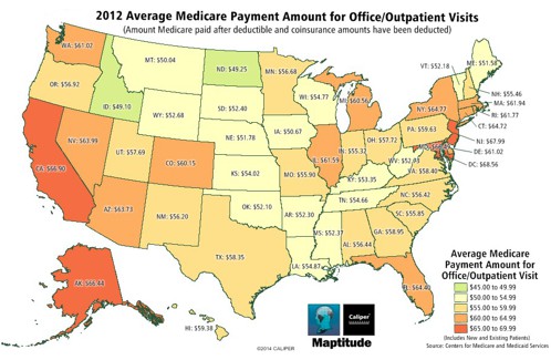
Featured Maptitude Map:
Average
Medicare Office Visit Payments by State
(USA)
This map, made with Maptitude 2014,
highlights regional variations in
Medicare payments for office visits.
States with higher payments than the
national average are shown in dark
orange
and states with lower payments are shown
in light green.

The average Medicare payment per office
visit by state was calculated using CMS data on services provided to Medicare beneficiaries by
health professionals.
This data can be used directly with
Maptitude, allowing analysts to explore
payment trends and identify unusual
provider and service patterns.
Government agencies and insurers can use
the data to identify high-priced
providers, potential fraud, and spot
location-based variations in the
patterns of care. Consumer groups may
use the data to identify high-volume or
low-volume providers in their attempts
to identify the best physicians.
When used with the Maptitude
2014 USA Country Package deeper
insights can be made into issues of
provision by socio-economic
characteristics by geography, using the
wealth of demographics provided with the
software (more...).
»
More Featured Maps
|
"Maptitude...has
a significantly flatter learning
curve than other GIS software.
You get a fully functional GIS
and extensive data for 1/3 the
price of other GIS products."
Dr. Dick Hoskins,
Washington State Department of
Health |
|
|
Tech Tip FAQ:
How do I
use company logos for point icons?
 Maptitude
maps
can be displayed in a wide variety of
ways, such as using custom company
logos for each location along with
automatic text labeling that identifies
each point. There is no limit to the
number of point styles that can be
applied in Maptitude. You can use any of
your own images, and the software
includes hundreds of icons that can
differentiate customers, locations, and
competitors. Maptitude
maps
can be displayed in a wide variety of
ways, such as using custom company
logos for each location along with
automatic text labeling that identifies
each point. There is no limit to the
number of point styles that can be
applied in Maptitude. You can use any of
your own images, and the software
includes hundreds of icons that can
differentiate customers, locations, and
competitors.
»
Learn How Here
|
|
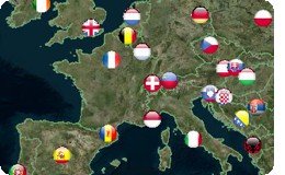
International:
2014 United Kingdom Country Package
Released
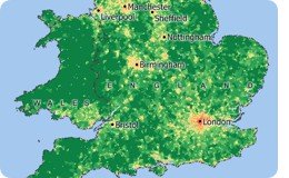
 The
2014 Country Package for the United
Kingdom now includes income data, plus
has many other demographic and map updates including
refreshed streets, postal boundaries and postcode
points! The
2014 Country Package for the United
Kingdom now includes income data, plus
has many other demographic and map updates including
refreshed streets, postal boundaries and postcode
points!
»
2014 UK Country Package
|
|
Tricks & Tips:
Show Labels & Features Directly From The Display Manager
 Maptitude
makes it easy to customize maps. You can
choose exactly those geographic features
and layers which you want to be visible. Maptitude
makes it easy to customize maps. You can
choose exactly those geographic features
and layers which you want to be visible.
Many items in the Display
Manager (accessed via
Map-Display Manager)
can be right-clicked to display
a context-sensitive menu that
allows you to change the
visibility of the item in the
map. For example you can choose
to show layers, labels, and
feature classes such as road types.
|
|
|
|
|
|
|

