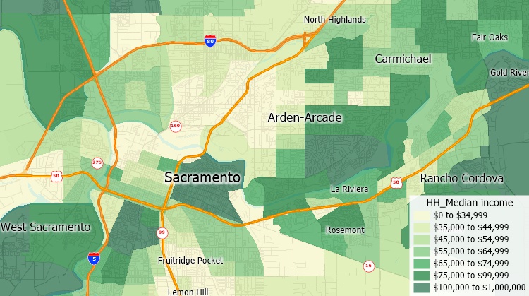
Maptitude includes a comprehensive collection of industry and population data that helps you to evaluate and identify the right markets for your organization. Maptitude demographic and business data for use in analytical and mapping applications are available in different formats. These include table formats for use in spreadsheets and databases. You can also choose from multiple datasets that are priced individually, allowing you to boost your geographical analysis by targeting your specific needs.
Detailed projections for United States Counties are filled with demographic estimates as far as 2100. Such estimates are broken down by year, race, and sex and include a variety of comprehensive population categories. Such accurate forecasts are ideal for strategic research, advertisement strategies, and for studies that require predicting possible population counts.
Unlike Woods & Poole, Maptitude includes data for many geographies including CBSAs, MSAs, Counties, MCDs, tracts, and more.
 |
CASE STUDY: How the United States Census Bureau Relied on Maptitude for the 2010 Census and for Tabulating Census Transportation Data |

Demographic data down to the Census tract level are included with Maptitude making it an ideal alternative to Woods & Poole

Maptitude replacement for Woods & Poole includes demographic projections
| Maptitude | Woods & Poole | |
|---|---|---|
| Annual Licensing | $695 for whole US | $395 per state / $4,500 for whole US |
| Demographic/Economic Data | Whole USA | USA or per state |
| Data for Counties and Above | Included | Included |
| Data for Census Tracts | Included | Not Available |
| Data for Census Block Groups | Additional $250 | Not Available |
| Data for Census Blocks | Additional $795 | Not Available |
| Data Visualization (e.g., heat maps, charts) | Included | Not Available |
| Data Analysis (e.g., radius reports) | Included | Not Available |
Prices from https://www.woodsandpoole.com/our-databases/united-states/all-geographies/ as of 6/24/2020

|
“Maptitude includes Census, ACS, and FFIEC income data that saves us many hours of searching, selecting, downloading, sorting and combining data.”
|
 |
“Maptitude is truly a complete product at $695, including an accurate...geocoder, extensive cartography..., and demographic estimates and projections at the census tract level. Optional data sets are very reasonably priced and include further geographic detail and versions for 20 different countries.”
|


Maptitude |
The best mapping software and Woods & Poole replacement! Here's why:√ Maptitude is the easiest-to-use full featured mapping software, and includes powerful tools such as multi-ring drive-time zones √ Maptitude has no subscription fees, and supports secure off-line data storage
√ Maptitude provides fully customizable maps with unlimited point icons √ Maptitude has unlimited pin-mapping/geocoding √ Maptitude includes free mapping data and demographics covering everything from population statistics to business locations, postal/ZIP Codes, and more! |
 Check out our G2 Reviews
Home | Products | Contact | Secure Store