By Stewart Berry
27 December 2024
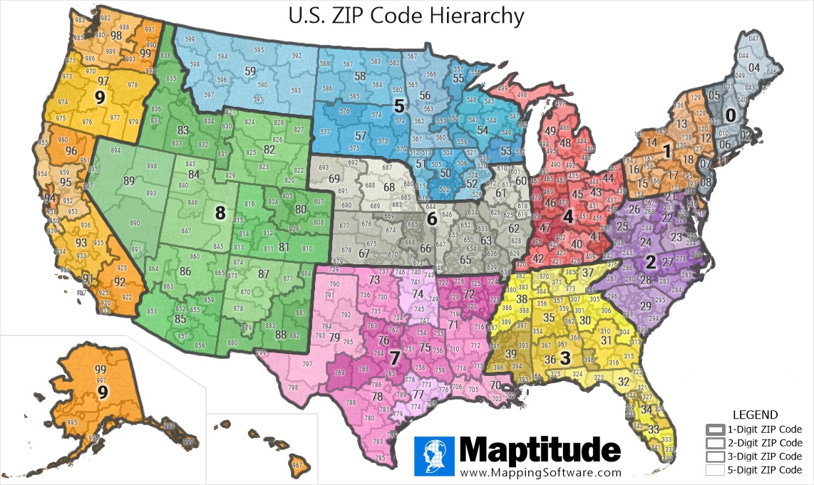
Territories by ZIP Code: Maptitude includes the complete ZIP Code Hierarchy Data
Maptitude allows you to quickly and easily map and explore ZIP Codes with your own data. No coding is required. You can show information by ZIP Code boundary, create territories, or analyze postal geography.
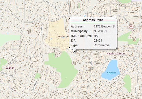
Maptitude provides the most accurate ZIP Code boundaries available. In addition, you can precisely map addresses, PO Boxes, and carrier route centroids.
ZIP Code mapping software is a powerful tool that can help you visualize data and make better decisions. It allows you to create maps using ZIP Codes as geographic units, so you can see how data is distributed across a specific area. This can be useful for a variety of purposes, such as:
If you are looking for a powerful and versatile tool to help you visualize data and make better decisions, ZIP Code mapping software is a great option.
Get access to ZIP Code territory tools, ZIP Code heat maps, and many more advanced features by signing up for a free trial today!
Here are some of the benefits of using ZIP Code mapping software:
If you are looking for a ZIP Code mapping software solution, be sure to consider the following factors:
Once you have considered these factors, you can start shopping for ZIP Code mapping software. There are a variety of solutions available, so you can find one that meets your specific needs.
Maptitude is a powerful and easy-to-use mapping software solution that can help businesses of all sizes to improve their decision-making.
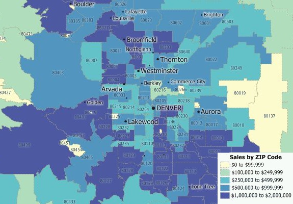
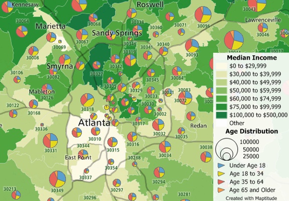
Maptitude will aggregate your sales data by ZIP Code so you can better understand the geographic component of your data
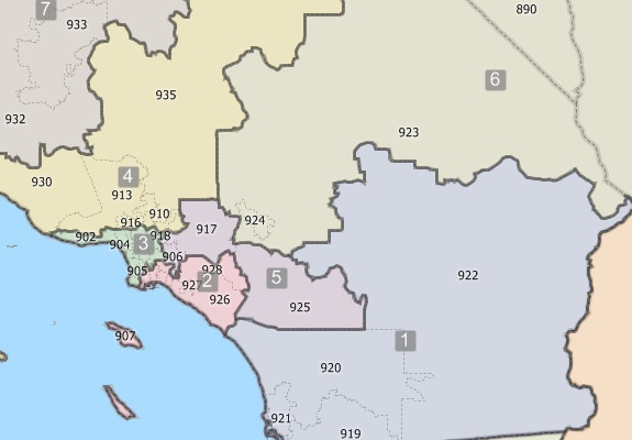
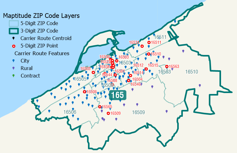
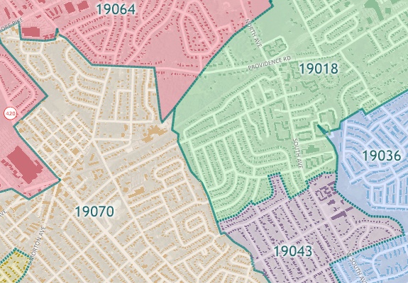
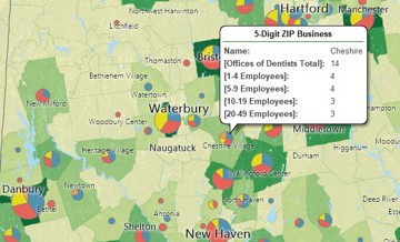
Create your own balanced territories using 3-Digit ZIP Codes (above) or 5-Digit ZIP Codes


|
“The best mapping software you'll ever need. I've been using Maptitude since the mid-90's. I love the 3 & 5 digit ZIP boundaries and demographic data that comes with it. To be honest, we originally bought it because it was the easiest way to acquire Census data. Since then we have continuously used it for a wide range of client projects. I have to admit it has way more power than I have explored... they keep adding features - I've made tons of use of the themes (you can color the maps with backgrounds based on the included geodemographics). I've also used the band feature - retailers LOVE it. I recommend it ALL THE TIME!”
|

The Maptitude U.S. Country Package includes extensive demographic data at the ZIP Code level so you can better understand your market.
Create ZIP Code Maps

|
“Flexibility of working with different layers of data. Being able to combine my data with demographic data within counties, drive-time rings or zip codes is invaluable.”
|
|
“[Maptitude] enables you to see all kinds of relationships that may not have been clear before: Maybe your product sells three times better in ZIP codes where the median age is under 35 than in areas where it is over 45.” Los Angeles Times |
Whether you are looking to perform a direct mail campaign, identify addresses in a ZIP Code or sales territory, or route to all addresses in an area, Maptitude meets your needs for only US$695 annually.
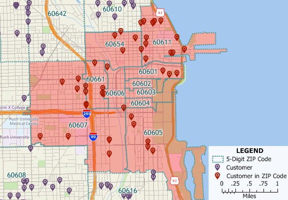
Maptitude includes 3-digit and 5-digit ZIP Code boundaries, as well as ZIP Code points. You can easily identify all the postal areas in your market or delivery areas. And you can identify all the businesses by NAICS code in your chosen ZIP Codes, identify individual business along with address and phone number, and get demographics and residential address points.
Accurate ZIP Code boundaries for creating direct mail maps
Over 48 million address points in 22 states for precise direct mail address maps and routes

|
“We are able to do things with Maptitude that we had not dreamed of doing before (using MapPoint and Territory Mapper). For example, it has been extremely valuable to show our customers the density of their territory by ZIP Code.”
|
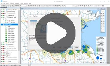
1. Sign up for a free Maptitude Online trial account.
2. Follow these simple steps to enter your list of ZIP Codes.
3. Maptitude Online creates the ZIP Code map, switches to the Maps tab, and adds the map as a new card that you can now view.
You may have an Excel file of ZIP Codes that you want to display in a map. You can use Maptitude to open your files and convert them into a map that you can insert in Excel.
Analysts often want to be able to see their Excel sheets on a map. Maptitude has tools that make it easy to export mapping results to the Excel file formats. Maptitude supports both the import and export of XLS and XLSX file types. This allows you to also map data that you or others have created.
1. Locate your data in Maptitude. You can do this by following the steps here: https://www.caliper.com/learning/media/creating-a-maptitude-map-using-your-own-data/.
2. Make sure your new layer is the working layer.
3. Export to an image format using File>Export>Image, making sure to choose a file format you would like to insert into Excel, and click Save.
4. Drag and drop the image file you saved from Windows Explorer into Excel.
Learn more about Maptitude to see how you and your team can benefit from mapping software!
 Check out our G2 Reviews
1 https://www.uspsoig.gov/sites/default/files/reports/2023-01/rarc-wp-13-006_0.pdf
Home | Products | Contact | Secure Store
