
Author:
Stewart Berry
Images: Dan Martin

Maptitude is used by marketing and sales professionals in industries as varied as healthcare, franchising, communications, logistics, retail, real estate, banking, consulting, and many more. Every single one of these analysts needs to efficiently process their business data so that they can make actionable decisions that benefit their organization and their clients.
Maptitude provides the tools, data, and insights that enable organizations to make informed choices using the map as the medium to visualize, share, and understand data. Here are 4 key areas where Maptitude will prove to be critical to your organization:
Maptitude is the perfect solution for those that want to leverage location-based analytics, and when they want to do it now. Open or log in to Maptitude and use the Wizard-driven tools to complete tasks that would be impossible in most other mapping or Geographic Information Systems without considerable cost and time. You also do not need to switch to other applications for visualizations such as charts, and conversely, Maptitude allows you to keep your data in the formats you are most familiar with, reading directly from many file types such as Excel.


Maptitude includes the most up-to-date and accurate data available that encompasses expenditure, geodemographic segments, population projections, gross domestic product, medical and banking locations, branded business locations, traffic counts, and the tools to leverage this information to improve the location intelligence of any organization. Free USA data include building footprints and address points that are useful for site evaluation, direct mailing, and deliveries. While the financial assets dataset is essential for any organization that relies on wealth-related statistics.

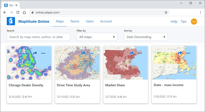
Taking tabular data and mapping it to find strengths, weaknesses, opportunities, and threats gives your organization a competitive advantage. The intuitiveness of graphs and charts are why maps are so appealing in that they allow you to understand trends that would otherwise be hidden. But these benefits are not limited to the analyst working with Maptitude. Maptitude Online is the latest addition to the product suite and provides a simple way to extend the reach of your work to others in your organization or publicly. Maptitude Online Private provides user logins to manage who can access which maps and comes with a comprehensive range of team management tools. Share this map with the C-suite? And only these maps with this sales team? Maptitude makes such workflows trivial to implement. Once users are viewing your results they can zoom and query maps, pushpins, routes, territories, and your data and reports. The features in the map can be turned on and off and can be saved for use offline as image files and PDFs. Maptitude Online Public allows you to share a URL even without user logins, and to brand the map with your company name, logo, and web domain.

Geographical Information Systems (GIS) are hard to use. Maptitude is different. Often, GIS are designed for those with specialized knowledge. In many instances GIS are not optimized for results and benefits, typically because key datasets, maps, and tools are an additional cost, and are treated as add-ons to the core product. Maptitude is streamlined to allow you to start with your data and to obtain the answers you need as soon as you begin working with the application. Key datasets are built into Maptitude, with free industry specific packages available for download.
Maptitude builds on this foundation with speed and usability enhancements. Maptitude is faster with improvements to routing for multiple destination directions, quicker display of imagery and aerial layers, and more rapid opening and closing of maps.
Maptitude has emerged as the ideal replacement for MapPoint. One of the best features of MapPoint was being able to use sliders to adjust driving speeds by road type to make travelling along them faster or slower. Maptitude has taken this a step further by allowing you to explicitly define speeds. This allows you to better control your route and directions models based on the likely speeds your vehicle types will use when travelling on different categories of roads. This can be used for local routing or for long haul market analysis that is now quicker and easier to visualize.
Often multiple tables of locations are added to a map representing for example, customers, competitors, and facilities. One of the many features is the automatic use of different colors for new pushpins. Such changes reflect our attention to user needs and this constant improvement of the interface shows our commitment to making sure that Maptitude continues to be the easiest to use mapping software on the market.

There are many more improvements in Maptitude. For more information on Maptitude GIS Software please visit https://www.MappingSoftware.com.
Maptitude ensures that your sales and marketing mapping projects and reports will be a success. By integrating with key geographic, business, and consumer datasets, Maptitude provides a one-stop wizard-driven interface. Maps are an intuitive way to convey and analyze large amounts of data. Maptitude can support all the above analytics and comes with all the data used in the examples shown, as well as information for almost any industry and sector you would need to map.
Learn more about Maptitude to see how you and your team can access the data critical to making successful business decisions!
Schedule a Free Personalized Demo

Home | Products | Contact | Secure Store